|
A further update to our recent British Empire Exhibition blog. Despite believing that the soon to be demolished Palace of Industry was the last remaining remnant of the exhibition, it appears there may be one or two more.... The site of the 1925 exhibition covered 216 acres, south from Wembley Park station to the present day Wembley Stadium, a small area to the west of this and a much larger area to the east. The majority of the area to the west was made up of national pavilions, providing a taste of the architectural traditions and produce of the nations of the empire. This included such sites as a Burmese pagoda, Nigerian adobes and many more. This area is now made up of industrial units and offices, which replaced pavilions which were demolished or removed to other places.. However it seems there may still be some remnants of the exhibition in this area. 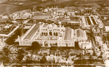 Aerial Image of the India Pavilion 1924. The most interesting and obvious one in the Indian Pavilion. The pavilion was jointly modeled on the Jama Masjid in Dehli and the Taj Mahal in Agra and was designed by the firm of Sir Charles Allen and Sons. Inside it was divided into 27 courts each focusing on products from the 27 provinces of India. Unfortunately the centerpiece central dome section is no longer there, but the the flanking buildings remain. These buildings have been turned into businesses, one is Latif Rugs, the other is Stonemanor Ltd. That they are the remains of the India Pavilion can be quite clearly seen by comparing an image of the present day area from Google Earth with the same area from a map of the exhibition.  Part of the India Pavilion, now Latif Rugs. Much of the outside of the buildings has been covered in metal cladding but a look at the side of the structure shows a similar makeup to the Palace of Industry, which was constructed of concrete and precast concrete blocks. 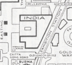 Detail showing the outline of the India Pavilion in 1924. 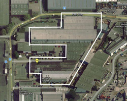 Detail showing the outline of the Latif Rugs and Stonemanor premises 2013. Another building a bit further east also appears to be a leftover from the exhibition. It again seems to be constructed from a similar material to the Palace of Industry and the India Pavilion, and the shape of the building is the same on Google Earth and the exhibition map. According to a map in Sir Owen Williams 1890-1969 by David Cottam, it is a canteen or restaurant. This building now contains several companies, including Rubicon the soft drinks manufacturer. 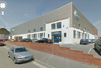 Former canteen building, now Rubicon offices. 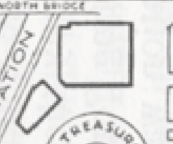 Detail of map showing the canteen buildings in 1924. 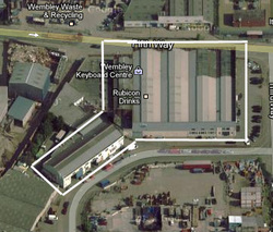 Detail of map showing outline of Rubicon Offices 2013. I have no verification for these buildings at the moment, but the evidence points towards them being relics of the exhibition. If so they will be the only remaining structures from the period and an important piece of Metro-Land and Brent history. Of course given their track record we won’t be expecting Brent Council to spring into action and support the listing of the buildings, but at least there will hopefully be some traces of the British Empire Exhibition when its 100th anniversary occurs in 2025.
4 Comments
Brian Polley
12/4/2013 04:19:08 pm
I can confirm that the 'Rubicon' site buildings were in use as restaurants for visitors to the Exhibition. A map of the exhibition site in a leaflet published by the London General Omnibus Company shows the various eating places on the map, graded from A to E, A being De Luxe Service. The larger of the two is 'Lyons' Popular Cafe Service (grade C), and the smaller is 'Lyons' Teashop Service' (grade E).
Reply
13/4/2013 03:02:33 am
Hi Brian ,
Reply
Richard Stokes
8/10/2019 05:39:44 pm
The man who designed the Indian pavilion was Sir Charles Allom, not Allen.
Reply
8/10/2019 07:11:14 pm
Hi Richard,
Reply
Leave a Reply. |
Archives
May 2024
Categories |
 RSS Feed